Communication Basics · Satellite Communications
#12 GEO/LEO/MEO definitions, ideal propagation delay, transponder chain, satellite bands, VSAT, and LEO broadband
Solve a satellite link through path geometry, allocation, transponder, antenna, link budget, and end-to-end latency instead of orbit labels and catalogue rates.
Question
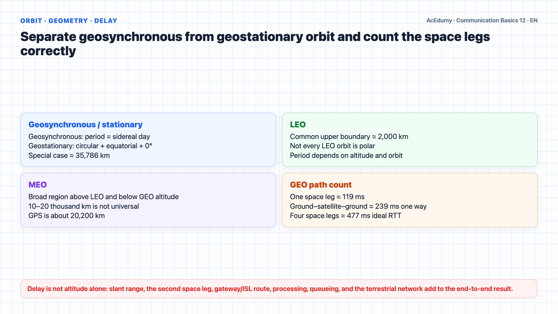
Separate geosynchronous from geostationary orbit; count one space leg, one-way ground-to-ground path, and RTT correctly; do not reduce LEO user latency to altitude; place L/C/Ku/Ka bands inside service and regional allocation.
Written solution and narration transcript(shows the full solution)
Below are all the lines written in the notebook together with the full narration transcript.
1. Correct geosynchronous/geostationary definitions and GEO–LEO–MEO delay boundaries
Altitude gives only an ideal space-propagation lower bound; the real link also includes slant range, two space legs, gateway, routing, processing, queueing, and link budget. Satellite communication uses microwave signals, but instead of terrestrial towers, the relay is in space.GEO, MEO, and LEO are useful communications classes; their boundaries are not one universal three-bin standard and depend on mission and authority.A geosynchronous orbit has a sidereal-day period. Its circular, zero-inclination equatorial special case is geostationary, at an altitude of about 35,786 km.A geostationary satellite moves in Earth's direction with the same angular period and appears over one longitude; not every geosynchronous orbit is geostationary.This makes GEO ideal for television broadcasting and weather monitoring.One 35,786 km ground–GEO space leg is ideally about 119 ms. A two-leg ground–satellite–ground one-way path is at least about 239 ms, and a four-leg ideal RTT about 477 ms, before processing and terrestrial routing.For voice calls this delay is noticeable and can be disturbing.A common LEO upper boundary is about 2,000 km; 320–1,500 km describes selected missions and constellation shells, not the whole class.Lower LEO periods can be about 90–120 minutes; not every LEO orbit is polar.LEO constellations can reduce space-propagation delay relative to GEO. User latency also includes slant range, gateway/inter-satellite route, processing, queueing, and the terrestrial network; 20–40 ms is not universal.MEO is the broad region above LEO and below geosynchronous altitude; 10,000–20,000 km covers some navigation examples, not a universal boundary.The most famous MEO system is GPS, the Global Positioning System, at about 20200 kilometers.Unlike GEO, LEO and MEO satellites do not maintain fixed positions relative to the ground and require tracking or handover between satellites.Narration transcript
Satellite communication uses microwave signals, but instead of terrestrial towers, the relay is in space. There are three main types of satellite orbits. GEO, Geosynchronous Earth Orbiting satellites, are positioned at an altitude of 35786 kilometers directly above the equator. They orbit at the same speed as Earth's rotation, so they appear stationary from the ground. This makes GEO ideal for television broadcasting and weather monitoring. However, the great distance creates significant propagation delay: about 0.25 seconds one way from ground to satellite, meaning a round trip takes about 0.5 seconds. For voice calls this delay is noticeable and can be disturbing. LEO, Low Earth Orbiting satellites, fly at 320 to 1500 kilometers. They circle Earth in about 90 minutes in polar orbits. Originally used mainly for remote sensing and imaging, LEO has been transformed in recent years by massive constellations like SpaceX Starlink and OneWeb, which use thousands of LEO satellites to provide global broadband internet with much lower latency than GEO, typically 20 to 40 milliseconds. MEO, Middle Earth Orbiting satellites, are at altitudes of 10000 to 20000 kilometers. The most famous MEO system is GPS, the Global Positioning System, at about 20200 kilometers. Unlike GEO, LEO and MEO satellites do not maintain fixed positions relative to the ground and require tracking or handover between satellites.
2. Separate the transponder chain from shared antennas and place L/C/Ku/Ka bands in allocation context
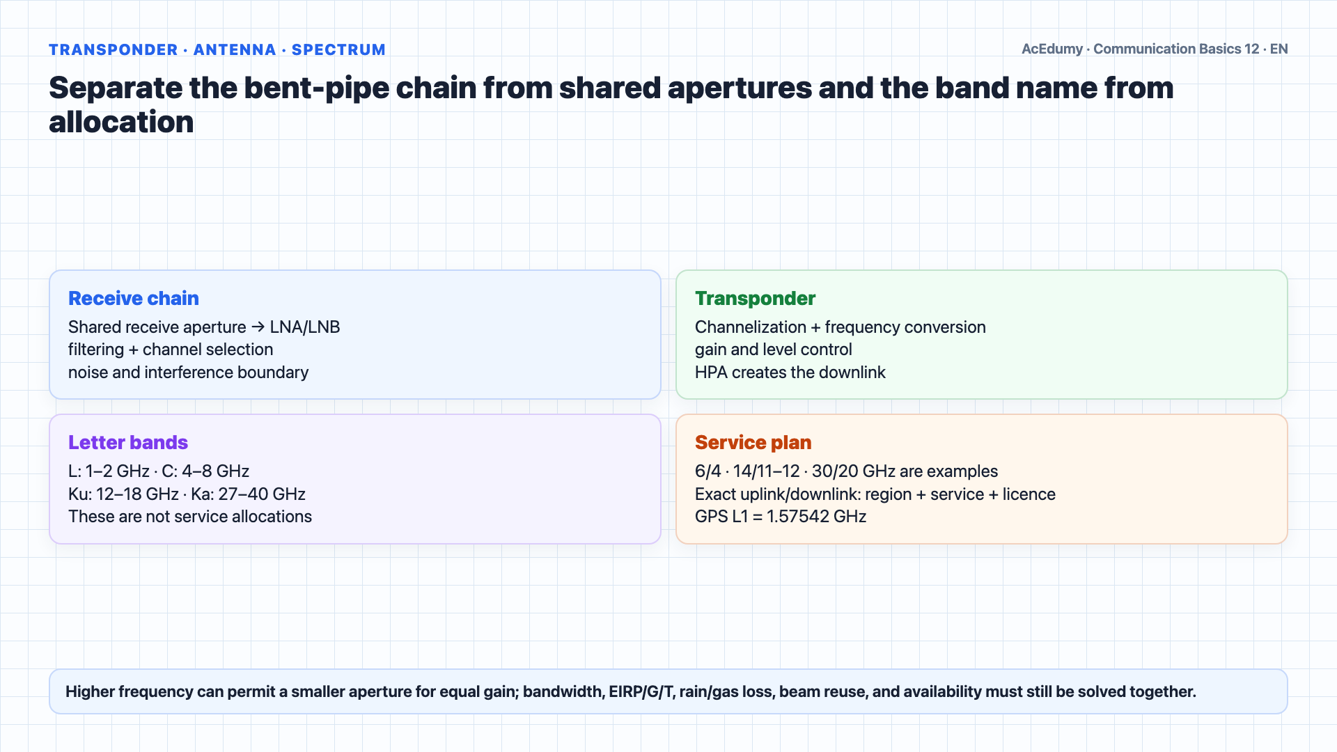
Altitude gives only an ideal space-propagation lower bound; the real link also includes slant range, two space legs, gateway, routing, processing, queueing, and link budget. The satellite's key component is the transponder.A bent-pipe transponder typically includes low-noise receive amplification, filtering/channelization, frequency conversion, and high-power transmit amplification; receive/transmit apertures may be shared across many transponders.A single satellite may carry dozens of transponders.On the ground side, a transmitting station sends data through a baseband processor, an up converter for frequency shifting, a high powered amplifier, and a parabolic dish antenna.The receiving station reverses this process.Satellite systems operate in several frequency bands.6/4 GHz is shorthand for selected fixed-satellite C-band plans; exact uplink/downlink allocations depend on service, region, and licence.It is widely used for commercial TV and VSAT networks.14/11–12 GHz is a common Ku FSS plan example. Higher frequency permits a smaller aperture for the same gain; actual antenna size follows EIRP, G/T, rain, and availability targets.30/20 GHz is a common Ka plan example. Wider allocations may support high capacity, but capacity is not guaranteed; rain/gas loss, spot beams, reuse, and link budget govern the result.The IEEE letter band called L is about 1–2 GHz; GPS L1 is 1.57542 GHz. Mobile and maritime satellite frequencies are selected by service and regional allocation.Narration transcript
The satellite's key component is the transponder. It contains a receiving antenna to pick up signals from the ground station, a broadband receiver, a frequency converter that shifts the signal to a different frequency for the downlink, and a high powered amplifier to send the signal back to Earth. A single satellite may carry dozens of transponders. On the ground side, a transmitting station sends data through a baseband processor, an up converter for frequency shifting, a high powered amplifier, and a parabolic dish antenna. The receiving station reverses this process. Satellite systems operate in several frequency bands. C band uses about 6 gigahertz for the uplink and 4 gigahertz for the downlink. It is widely used for commercial TV and VSAT networks. Ku band operates at around 14 gigahertz up and 11 gigahertz down, requiring smaller antennas than C band. Ka band uses about 30 gigahertz up and 20 gigahertz down, offering the highest capacity but being more susceptible to rain fade. L band at 390 to 1550 megahertz is used for mobile satellite services like GPS and maritime communications.
3. Bound DTH, GNSS, VSAT, and LEO broadband metrics by network and service conditions
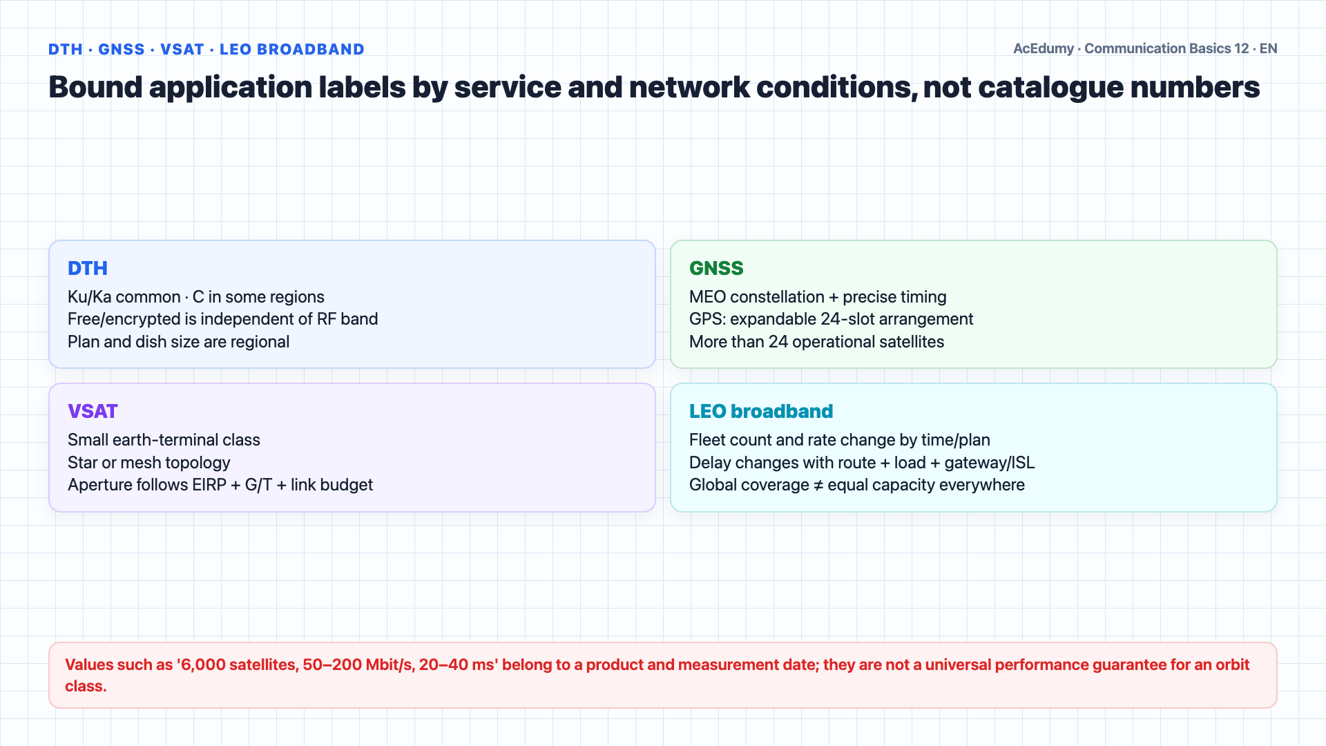
Altitude gives only an ideal space-propagation lower bound; the real link also includes slant range, two space legs, gateway, routing, processing, queueing, and link budget. Satellite communications serve many applications.Long distance telephony was one of the earliest uses, with the international Intelsat consortium connecting countries worldwide.DTH commonly uses Ku/Ka service plans and C band in some regional systems; whether a channel is free or encrypted is independent of RF band.Navigation relies heavily on MEO satellites, with GPS providing precise positioning for vehicles, aircraft, and smartphones.VSAT denotes a small earth-terminal class; aperture and star/mesh topology follow service, band, EIRP, G/T, and link budget. A 0.6–3.8 m interval is not a universal definition.VSAT can use C, Ku, or Ka allocations; banking, retail, maritime, and backup links are examples, not the only or mandatory solution.The biggest revolution in satellite communications today is LEO broadband internet.LEO broadband constellations may operate thousands of satellites. Fleet count, 50–200 Mbit/s, and terrestrial-like latency are time-, plan-, region-, and load-specific observations; capacity, terminal, route, and weather change them.This was unthinkable when satellite internet meant GEO with half second delays.Narration transcript
Satellite communications serve many applications. Long distance telephony was one of the earliest uses, with the international Intelsat consortium connecting countries worldwide. Television broadcasting is perhaps the most visible application: direct to home satellite dishes receive free or encrypted channels via C band or Ku band from GEO satellites. Navigation relies heavily on MEO satellites, with GPS providing precise positioning for vehicles, aircraft, and smartphones. VSAT, Very Small Aperture Terminal networks, use small dish antennas of 0.6 to 3.8 meters in a star topology connecting remote sites to a central hub. VSATs operate in Ku or C band and are essential for banking, retail, and corporate networks in remote areas. The biggest revolution in satellite communications today is LEO broadband internet. Starlink alone has deployed over 6000 satellites providing internet access to users in remote and underserved areas at speeds of 50 to 200 megabits per second with latency comparable to terrestrial connections. This was unthinkable when satellite internet meant GEO with half second delays.
4. Audit the GEO ideal-delay calculation by space leg, one-way ground path, and RTT
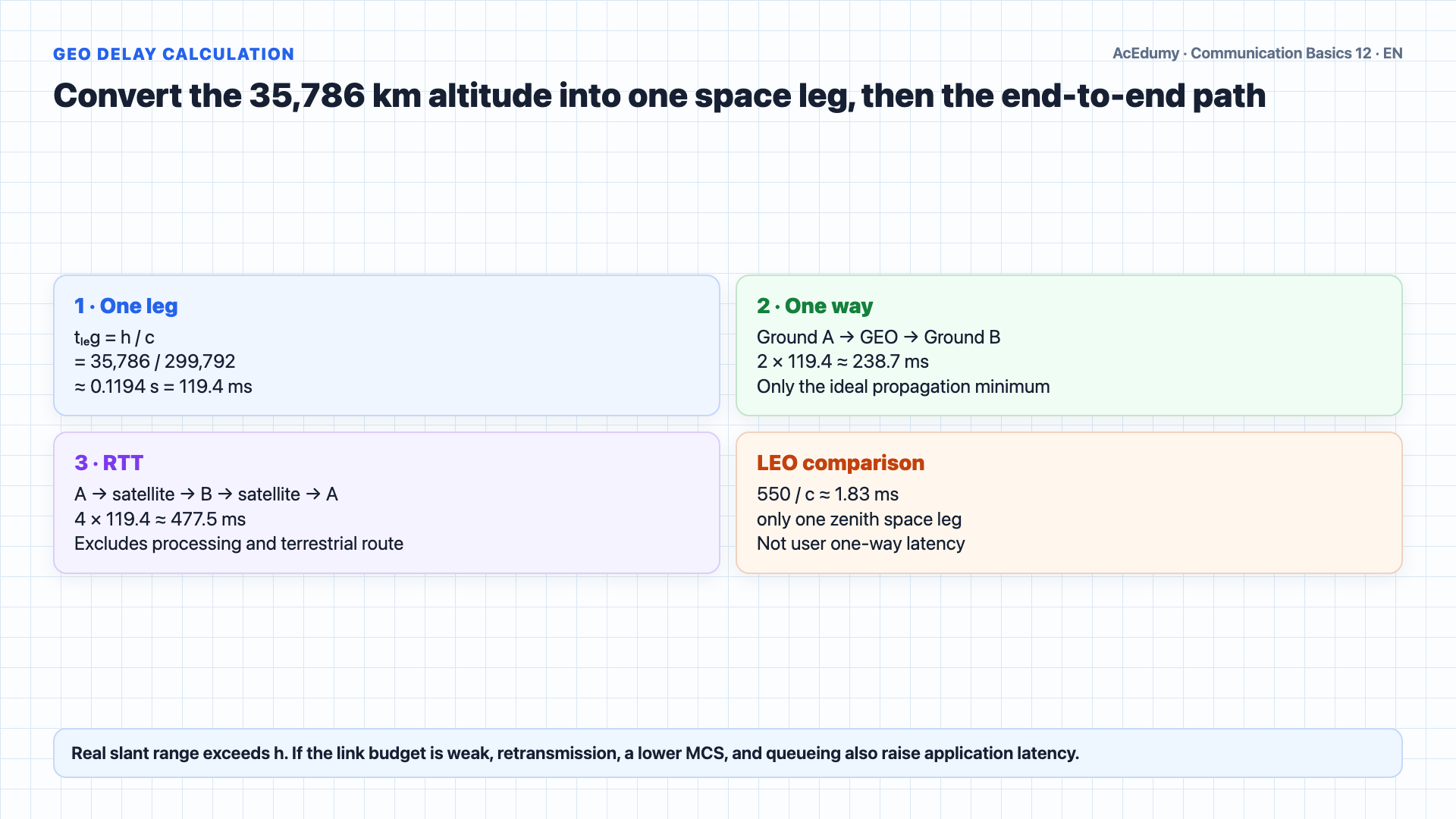
Altitude gives only an ideal space-propagation lower bound; the real link also includes slant range, two space legs, gateway, routing, processing, queueing, and link budget. Let us calculate the propagation delay for a GEO satellite link.Given: a GEO satellite at an altitude of 35786 kilometers.The speed of electromagnetic waves is approximately 300000 kilometers per second, the speed of light.Step 1: Calculate one way delay.Delay equals distance divided by speed.Delay equals 35786 divided by 300000, which equals approximately 0.119 seconds, or about 120 milliseconds.Step 2: For a ground to satellite to ground path, the signal travels up and back down, so the one way ground to ground delay is about 0.24 seconds, or 240 milliseconds.Step 3: For a full round trip, when you say hello and wait for the response, the total delay is about 0.48 seconds, nearly half a second.This is why GEO is problematic for voice calls and real time applications.550 km / c ≈ 1.8 ms is only the ideal lower bound for one zenith ground–satellite leg. A ground-to-ground path needs at least two space legs plus slant geometry, routing, processing, and queueing; low altitude helps interactive service but does not guarantee it.Narration transcript
Let us calculate the propagation delay for a GEO satellite link. Given: a GEO satellite at an altitude of 35786 kilometers. The speed of electromagnetic waves is approximately 300000 kilometers per second, the speed of light. Step 1: Calculate one way delay. Delay equals distance divided by speed. Delay equals 35786 divided by 300000, which equals approximately 0.119 seconds, or about 120 milliseconds. Step 2: For a ground to satellite to ground path, the signal travels up and back down, so the one way ground to ground delay is about 0.24 seconds, or 240 milliseconds. Step 3: For a full round trip, when you say hello and wait for the response, the total delay is about 0.48 seconds, nearly half a second. This is why GEO is problematic for voice calls and real time applications. In contrast, a LEO satellite at 550 kilometers has a one way delay of only about 1.8 milliseconds, making LEO ideal for interactive applications.
5. Summarize satellite design through orbit, spectrum, link-budget, and network-latency gates
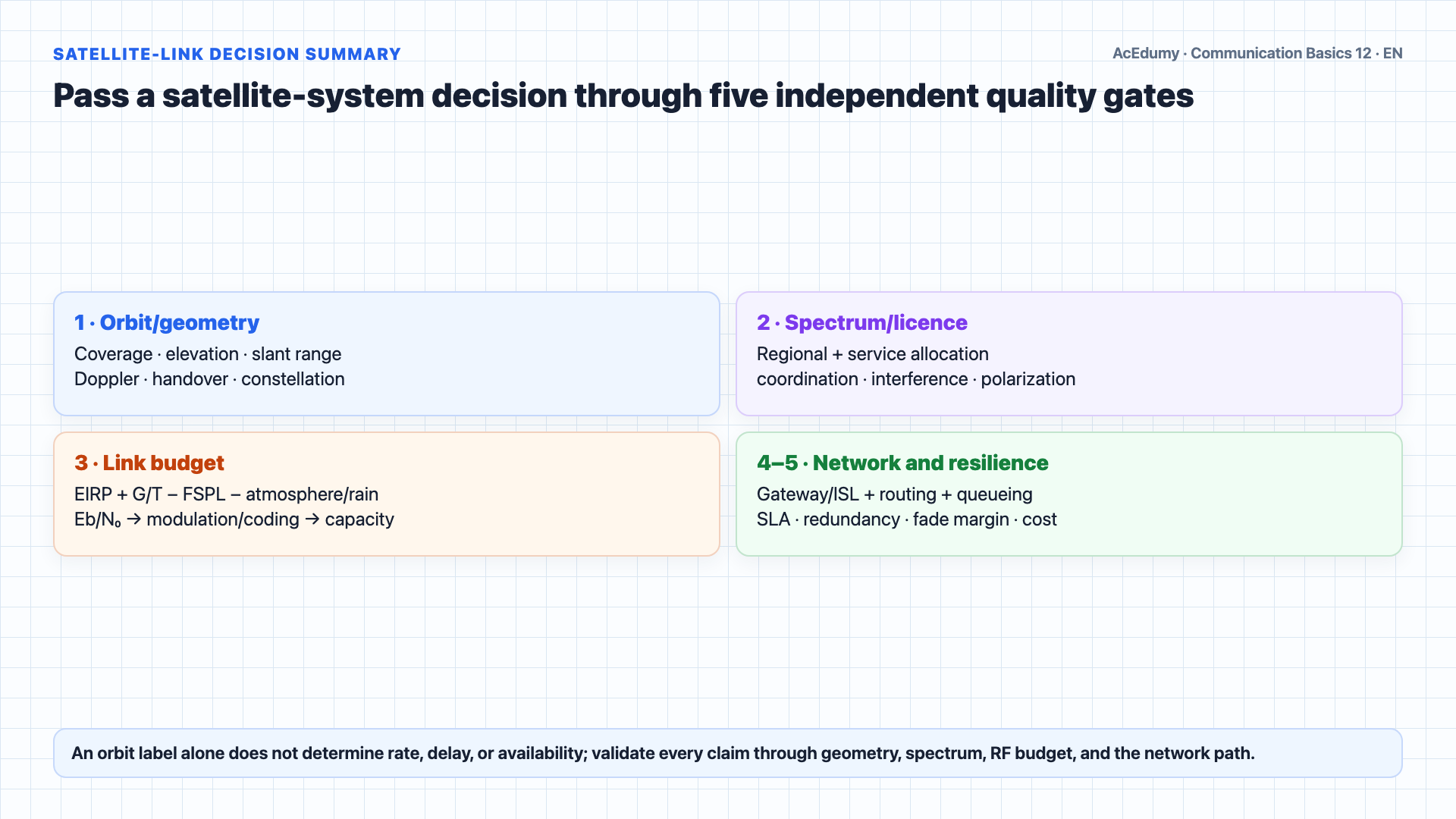
Altitude gives only an ideal space-propagation lower bound; the real link also includes slant range, two space legs, gateway, routing, processing, queueing, and link budget. Let us review.A geostationary satellite at 35,786 km appears over one longitude; one ideal space leg is ≈119 ms and a two-space-leg ground-to-ground one-way path ≈239 ms.Ideal for broadcasting and weather, problematic for voice.LEO commonly covers orbits below about 2,000 km; the shorter path supports low delay, while coverage and continuity depend on constellation, gateways/inter-satellite links, and capacity planning.MEO spans a broad altitude region; GPS flies at about 20,200 km in an expandable 24-slot arrangement with more than 24 operational satellites.Transponders convert and amplify signals between uplink and downlink frequencies.C/Ku/Ka examples must be mapped to service and regional allocation; capacity follows usable bandwidth, beam reuse, EIRP/G/T, interference, and link budget rather than the band label alone.VSAT networks connect remote sites in star topology.The LEO broadband revolution has transformed satellite from a high latency last resort to a competitive broadband technology.In the next lesson, we will explore fiber optic communications: Snell's law, total internal reflection, and singlemode versus multimode fibers.Narration transcript
Let us review. GEO satellites at 35786 kilometers appear stationary but suffer 0.24 second one way delay. Ideal for broadcasting and weather, problematic for voice. LEO at 320 to 1500 kilometers offers low latency and now provides global broadband via constellations like Starlink. MEO at 10000 to 20000 kilometers hosts GPS navigation. Transponders convert and amplify signals between uplink and downlink frequencies. Key bands: C band for TV and VSAT, Ku for direct to home, Ka for high capacity. VSAT networks connect remote sites in star topology. The LEO broadband revolution has transformed satellite from a high latency last resort to a competitive broadband technology. In the next lesson, we will explore fiber optic communications: Snell's law, total internal reflection, and singlemode versus multimode fibers.
Source video: Communication Basics #12 — Satellite Communications (7:34)